Personal note: Whilst it destroys the forests of Indonesia, Malaysia is increasingly keen to save its own. China has been doing much the same things for years.
--------------------------------------------------------------------------------------------------
New Straits Times Online
2008/12/28
Eye in sky to deter illegal loggers
SIX hours. That is all the time it takes to detect illegal logging in Peninsular Malaysia, thanks to the Forestry Department’s eye in the sky. Called the ‘Forest Monitoring Using Remote Sensing’ system, it was jointly developed with the Malaysian Remote Sensing Agency. Agency director-general Datuk Darus Ahmad and Forestry Department Peninsular Malaysia deputy director-general Datuk Razani Ujang talk to SONIA RAMACHANDRAN about the system.
Datuk Darus Ahmad says the satellite images are also used to build a national forest inventory.
Datuk Razani Ujang says the Forestry Department will verifies whether what is on what is seen on the satellite images and on the ground is the same.
Q: Whose idea was the system?
A: The satellite-based computerised system was mooted by the Malaysian Remote Sensing Agency and the Forestry Department and it started on the instructions of Deputy Prime Minister Datuk Seri Najib Razak who chaired the 20th National Forest Council meeting in September 2006.
Q: When was it completed?
A: It was completed in August this year and launched in October. The agency manages the system which is used by the department.
Q: What does the system do?
A: It monitors both licensed concession areas to detect compliance with regulations as well as high potential areas for illegal land clearing.
By identifying illegal land clearing, we can detect forest fires and help in haze prevention.
The images are also used to build a national forest inventory of the country's total area of forest cover.
This can be used to estimate the timber volume from the forests.
Q: Why do we need an inventory?
A: The inventory contributes to the national effort for forest and environmental sustainability.
There is always criticism that our forests are diminishing.
Q: How does it work?
A: We receive the data from the French Spot (Satellite Pour l'Observation de la Terre earth-observing satellites) through our ground receiving centre in Temerloh and it is processed within six hours.
The data is then placed in our database which is linked to the department.
To access any information, the department gets on to the Internet and calls up the specific page to check if logging carried out in that area is legal. The department will also go down to the field to check.
Q: What is considered illegal logging?
A: Logging outside the concession area as well as in protected areas such as riverbanks, areas above 1,000m and slopes of more that 40 degrees gradient. Also illegal is the building of logging tracks outside the logging concession area as well as logging of prohibited trees.
Q: How often are the images taken?
A: For licensed logging areas as well as sensitive areas, we take the images once a week.
Sensitive areas are those with high potential for forest clearing and the Spot satellite, which has a 2.3m resolution which can detect individual trees, passes over the same spot once a week.
For less sensitive areas, which consist of normal forest cover, the images are taken monthly.
Q: Does the system cover the whole country?
A: Currently the system is only for Peninsular Malaysia because we are working with the Forestry Department of Peninsular Malaysia. We can always extend it to Sabah and Sarawak.
Q: How much did the system cost?
A: Only RM120,000. The system was built using existing resources and internal expertise.
Q: Can the images be used as evidence in court?
A: Satellite images have been used to prosecute land owners for open burning so this has potential to be used as evidence in court.
That was a manual system where the image has to be interpreted manually.
This system has all the relevant data incorporated into it, including the template for licensed land boundaries, so it is immediately known that an offence is being committed.
Q: What is the difference between this system and the airborne hyperspectral imaging kit that has a sensor hooked to a computer and global positioning system device?
A: That is an airborne system. Our satellite system is more reliable and cheaper as we don't need an aircraft to operate it.
Our system will also have more frequent images and cover a wider area and it is linked online to the Forestry Department.
Q: What happens when you receive the images?
A: The satellite images are acquired by the Malaysian Remote Sensing Agency and processed.
When the end product is obtained, it will be sent to us and we will access it online. We will then verify the images.
We have a Geographic Information Section (GIS) which will produce hard copies of the images.
Verification can also be done by the state and district offices.
Then, we have to verify the images on the ground. This can be done by state, district or headquarters officers.
The results of this ground check will then be passed on to the enforcement unit.
Q: Why can't action be taken during the ground check? Why does the information have to be passed to the enforcement unit?
A: We have an enforcement unit at the headquarters and several at state forest departments.
By law, every officer posted to a state has to be gazetted in that state.
Only gazetted officers have the locus standi to carry out enforcement in the respective states.
There are plans to amend the National Forestry Act 1984 where federal enforcement officers will be gazetted to be able to carry out enforcement in the states.
Q: How long will everything take?
A: When the Malaysian Remote Sensing Agency receives the satellite images, it is in a raw form. The images can be full of distortions like lines, blurring or even cloud cover.
They have to be cleaned and aligned to the scales and coordinates.
The GIS unit will verify the data within two hours as it has to compare the images with our most current base map because the template used could be outdated due to changes in land use and new issuances of licences.
The verification part is to see if there is abuse. We have to ascertain whether what is on the imagery and on the ground is the same.
Our target is to complete everything within 24 hours.
Q: Do you have enough staff for all this?
A: We need dedicated officers to do the verification work and we need to employ them. At the moment, we have officers from different sections helping out.
Q: Can the images be used as evidence in court?
A: At present, the satellite images are not used to prosecute offenders. Only field evidence is used.
However, it has potential to be used as we have included it as an amendment to the National Forestry Act to be used as evidence.
http://www.nst.com.my/Current_News/NST/Sunday/National/2438061/
Article/index_html
Abuse and humiliation of orangutans stopped?

Good news. From March 29 2010 the use of orangutans in circus-like shows in Malaysia has been officially banned. Let us know at once if you see anyone breaking this law....this animal park was caught doing so by Nature Alert.
SHAME ON MALAYSIA

The government owned Melaka Zoo forces this orangutan to take part in degrading and inhumane shows. Note the lack of hair on this orangutan's arms and lower body.
Nine years secured to a three metre chain. Imagine if you will.

"Mely" enjoying fruit supplied by COP and Nature Alert.
Waiting to be rescued

Under lock and chain for at least nine years.
How governments do deals which wreck environments, people and countries

Highly Recommended reading and available from Amazon
Chained up day and night.

But confiscated and rescued by COP in January 2010.
COP to the rescue

The final moments before being released forever from the heavy chain around its neck.
A helping hand

After maybe nine years of being confined to a wooden crate this orangutan is now on the way to a rescue centre and one day back to the forest.
Highly Recommended Book

Available from Amazon and by far the best book ever written on orangutan conservation.
Another palm oil victim - one of tens of thousands - so far.

For a close up of this brutally treated orangutan, please see below.
Mother shot and eaten. Baby beaten and tied to a pole.

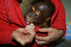
The plight of a baby orangutan rescued from a palm oil plantation workers in Borneo has exposed the high price these endangered primates are paying for the production of palm oil. The 2-3 year old female was found hogtied to a pole and had clearly been brutally beaten. Covered in cuts and bruises, she was also severely dehydrated and emaciated after being starved for days or even weeks.
Palm oil kills - no doubt about it.

Villagers protest against palm oil companies.
Tropical forest, home to orangutans etc.

Threatened by palm oil companies.
Saved by COP

Mother murdered by palm oil company
Tortured by palm oil company employees

Rescued and treated by COP, this orangutan has since been released back into a forest.
Palm oil plantation victim
Orphaned by a palm oil company with help from the government of Indonesia.
Indonesia's Alcatraz for orangutans

A living hell for this orangutan.
Guilty of being an orangutan

A prisoner held by the Indonesian government
Shame on the Ministry of Forestry
A life behind bars. Why?
Day after day, 24/7 ..........

A magnificent male orangutan facing life imprisonment behind bars.
Kept prisoner in filth and squalor

Things just go from bad to worse
Solitary confinement .

There can be no excuse for treating an orangutan like this.
Welcome to Indonesia

Where orangutans are incarcerated by the government.
No hope?

Has this orangutan lost the will to live?
Shame on Minister Kaban

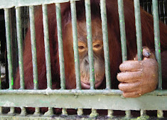
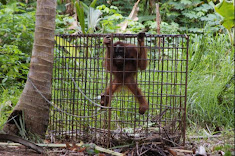
Young orangutan in a 1.5 sq. metre cage 24 hours a day and tormented by zoo visitors.
What future do you think this orangutan has?

How much longer can the Indonesian government carry on abusing and killing orangutans?
Born in the wild.

Life behind bars - where the government of Indonesia prefers to see its orangutans.
Dying for help

With their mothers slaughtered these baby orangutans face a life of torment, torture and hunger, thanks to the government of Indonesia.
Torture chambers for orangutans at an Indonesian zoo

These orangutans have been kept like this for nine months. Until Nature Alert and COP protested the cages were left outside in all weathers.
Solitary confinement courtesy of Indonesian zoo

Caged like this 24/7 for nine months, with no end in sight.
Formerly home to orangutans and other wildlife.

Part of the price we all pay for palm oil.
Can you see the rainforest?

No? That's the way the palm oil companies like to see things.
Begging for food - not for fun.

Reduced to begging for food, this orangutan (one of two) is in a unofficial zoo in West Kalimantan. Their enclosure has nothing but bare earth, no protection from a blisteringly hot sun, a concrete tube to shelter/sleep in and no fresh water to drink.
Bored and hungry - for as long as this orangutans lives

Born to be free. Imprisioned for life.
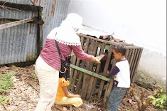
The COP Rapid Response Team

Their arrival in a remote village often generates a lot of interest. Please see July 2008 Blog page for more details..
Saved by COP

Please see July 2008 Blog page for more details.
Mother killed and her baby tied up like this for six months.

We found her at the home of a family who had bought her from her mothers killer. Please see photo immediately below - she is now safe, rescued by COP with the local Forestry Police.
Safe and sound - now

Saved by The Centre for Orangutan Protection and its sponsors/supporters.
Another palm oil victim

Rescued by COP and The Borneo Orangutan Survival Foundation
With its mother killed this orangutan's new owner keeps it chained up.

A baby orangutan with nowhere to go. A mother's love replaced with a chain.
How very, very sad.

What hope is there for this orangutan?
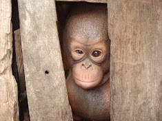
In this small crate there really is an orangutan.
Torture takes many different forms when it comes to dealing with orangutans.
Alone and abused.
Yes. There is an orangutan in this cage.
Chained to, rather than living in a tree.
There's no escape.
At a West Borneo amusement park.
Look at the rubbish this orangutan has to live with.
Escape is not an option.

same as picture below.
Yet another victim of logging and/or palm oil.

Alone, malnourished and very sad in a transit centre.
Palm oil companies take everything.

Imagine; this was once a rainforest.
Life imprisonment

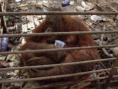
Five adult orangutans are crammed into this dark, featureless cage in a zoo. All five began life in the wild.
Orphaned by loggers or palm oil companies - often the same thing.

Missing its mother. Look at her eyes and you have to wonder what she is thinking don't you? STOP PRESS this baby has since died.
A little light refreshment goes a long way.

Water melon was always a firm favourite of the orangutans. In all the differnt locations we never once saw fresh drinking water provided.
A Tasty treat

Everywhere we went we took lots of different fresh fruit to give to the hungry orangutans we always discovered in various locations.
Same location as above.

We provided food and some small branches, and they loved both.
Again, the same location

We hope we made him a little happier than he appears. The lives of these two orangutans must be almost unbearable. We hope to arrange their transfer to a rescue centre soon.
West Kalimantan (Indonesian Borneo)

Two young orangutans kept at an amusement park. They were wild born. Mothers killed by loggers.
Rescued last year and now at a rehab. centre with an uncertain future.

This baby saw her mother being killed and eaten.
Lawbreakers

Illegal loggers
The torture of orangutans is seemingly never ending.

With its left arm chained and padlocked to its neck, this orangutan is literally being tortured at an amusement park in West Kalimantan (Borneo)
Awaiting rescue from what was once its home.

With nowhere left to run, this tranquillized orangutan was rescued and moved to another forest.
Apocalypse now - Indonesian style with help from Malaysian companies.

Rescuers looking for orangutans made homeless by a palm oil company. Virgin rainforest recently stood where there is nothing but a few small trees remaining, which by now will also have been cleared away. Nov. 2007
Yet another palm oil victim
-a.jpg)
With its mother killed, this baby with an injured eye was caged by workers until rescued by WWF Indonesia.
Illegal loggers in action. October 2007

Access to log these trees illegally was gained via a palm oil plantation road. This forest is home to 50 orangutans and palm oil companies want to log it.
The road to ruin - Indonesia style.

Where once stood a magnificent rainforest full of wildlife.
Mother and baby orangutan.

Oil palm companies have killed thousands like these two.
Palm oil victim. Mother killed.

This baby will have seen its mother slain.
Nothing, absolutely nothing, left of the forest, except for its soil.

It's all about money, greed and corruption.
Destruction and desolation as far as the eye can see

So much for Borneo's rainforests - look what palm oil companies have done to them.
They can barely cut down and remove the trees quick enough for their liking.

Palm oil companies destroy rainforests.
Freshly cut trees

These trees could end up as garden furniture in your local store.
Not a tree in sight - courtesy of oil palm companies.

Oil palm plants growing where rainforest once stood.